CAPE CORAL GEOGRAPHY
MACRO LOCATION IN FLORIDA
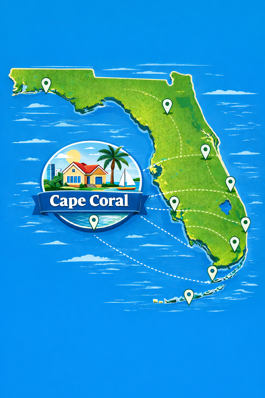
Cape Coral is located in Southwest Florida along the Gulf Coast, within Lee County. It sits roughly halfway between Tampa to the north and Miami to the southeast, placing it in one of the fastest-growing coastal corridors in the state. This region is known for its warm climate, waterfront access, and year-round outdoor lifestyle, making it a major destination for both relocation and second-home buyers.
REGIONAL POSITIONING AND NEARBY CITIES
Cape Coral is directly across the Caloosahatchee River from Fort Myers, which serves as the area’s primary commercial and cultural hub. Downtown Fort Myers offers restaurants, nightlife, offices, and a historic riverfront district, all just minutes away by bridge. To the southeast is Fort Myers Beach on Estero Island, known for its sandy shoreline and Gulf-facing views. To the west and southwest are Sanibel and Captiva Islands, which are recognized for their natural beauty, beaches, and boating lifestyle. To the northwest, Matlacha and Pine Island provide a more Old Florida setting with fishing, waterfront dining, and access to open coastal waters.
| Location | Distance | Drive Time |
|---|---|---|
| Fort Myers | 5–10 miles | 10–20 minutes |
| Naples | 45 miles | 50–60 minutes |
| Tampa | 130 miles | 2 hr 15 min – 2 hr 45 min |
| Orlando | 160 miles | 3 – 3 hr 30 min |
| West Palm Beach | 180 miles | 3 – 3 hr 30 min |
| Fort Lauderdale | 200 miles | 3 hr 30 min – 4 hr |
| Miami | 230 miles | 3 hr 45 min – 4 hr 30 min |
THE PENINSULA SETTING
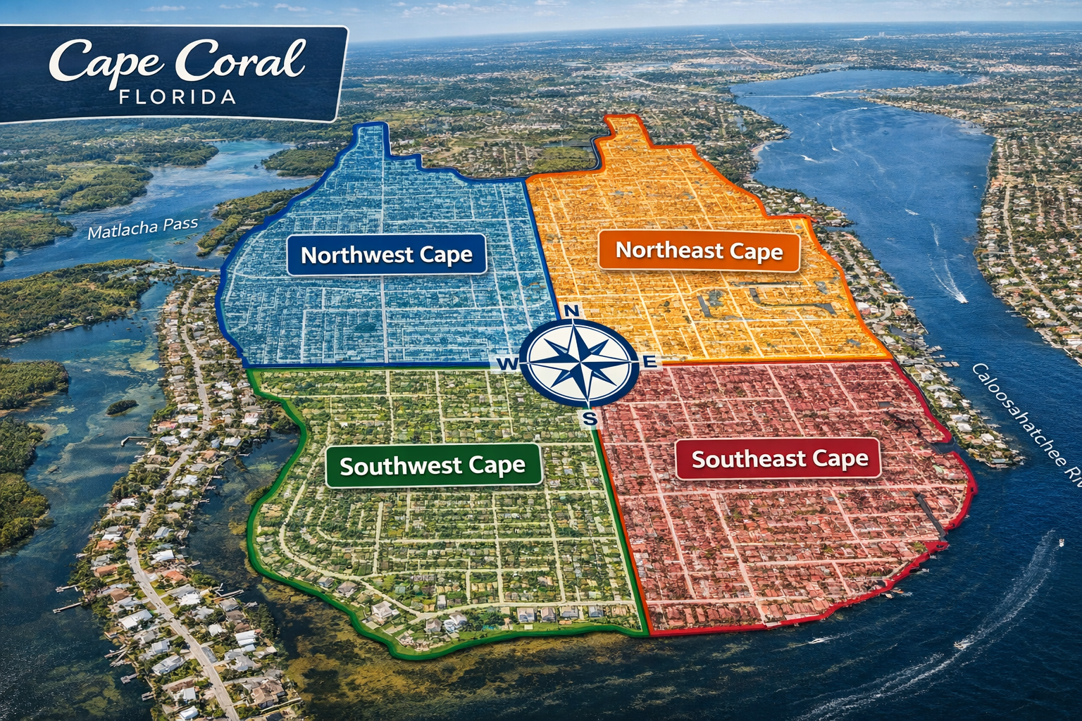
Cape Coral is best understood as a waterfront peninsula city. The Caloosahatchee River forms its eastern and southern boundaries, while Matlacha Pass borders much of its western edge. This positioning creates a city that is surrounded by water on multiple sides, with direct connections to inland waterways, coastal sounds, and the Gulf of Mexico beyond.
THE FOUR-QUADRANT LAYOUT
The city is organized into four primary quadrants: Southeast, Southwest, Northeast, and Northwest. This grid system is central to how Cape Coral is navigated and understood. The quadrants influence everything from commute times and neighborhood maturity to water access and future development patterns.
SOUTHEAST CAPE CORAL
The Southeast quadrant is the oldest and most established area of the city. It offers the closest proximity to Fort Myers and the main bridges crossing the Caloosahatchee River. This area typically features more mature landscaping, established neighborhoods, and convenient access to shopping, healthcare, and regional roadways.
SOUTHWEST CAPE CORAL
The Southwest quadrant combines strong residential appeal with convenient access to major corridors like Cape Coral Parkway and Pine Island Road. It provides a mix of established homes, newer construction, and canal properties. Its location also makes it well-positioned for reaching western waterways, Matlacha, and routes leading toward Pine Island.
NORTHEAST CAPE CORAL
The Northeast quadrant offers a wide range of residential development, often at a more accessible price point. It has seen steady growth and includes many opportunities for new construction. Its inland position provides easy access toward North Fort Myers and other parts of Lee County while still maintaining the structured layout of Cape Coral.
NORTHWEST CAPE CORAL
The Northwest quadrant is known for its newer development patterns, larger undeveloped areas, and long-term growth potential. It tends to feel less dense and more spacious, with increasing interest from buyers looking to build. Its location places it closer to Matlacha and the western coastal environment.
THE CALOOSAHATCHEE RIVER
The Caloosahatchee River is the defining eastern and southern boundary of Cape Coral. It separates the city from Fort Myers and serves as a major boating corridor connecting inland Florida to the Gulf of Mexico. Properties near the river often benefit from wider water views and quicker access to larger waterways.
MATLACHA PASS AND WESTERN WATERS
To the west, Matlacha Pass runs between Cape Coral and the communities of Matlacha and Pine Island. This area represents a transition from residential canal systems to broader coastal waters. It is a key route for boating, fishing, and accessing more open water environments.
PINE ISLAND SOUND
Beyond Matlacha Pass lies Pine Island Sound, a large body of protected water situated between Pine Island and the barrier islands. It plays a central role in the region’s marine ecosystem and boating network. For residents, it represents a gateway to expansive water views, wildlife, and access to surrounding coastal destinations.
CONNECTION TO THE GULF OF MEXICO
Cape Coral is directly connected to the Gulf of Mexico through a network of canals, river access points, and coastal waterways. This layered system allows residents to move from neighborhood canals to larger channels, then into open water. It supports a lifestyle centered on boating, fishing, and waterfront living without requiring direct Gulf-front property.
SANIBEL AND CAPTIVA ISLANDS
Sanibel and Captiva sit to the southwest and are among the most well-known destinations in Southwest Florida. They offer beaches, nature preserves, and a quieter island atmosphere. Their proximity adds significant lifestyle value, as residents can easily access these areas by car or boat.
DOWNTOWN FORT MYERS
Downtown Fort Myers is located just across the river and provides a contrasting urban environment. It features dining, entertainment, business services, and a walkable riverfront district. Its close proximity enhances convenience while allowing Cape Coral to remain primarily residential.
FORT MYERS BEACH
Fort Myers Beach offers direct Gulf shoreline access and is one of the region’s primary beach destinations. While Cape Coral itself is not a barrier island, its location allows residents to reach the beach within a reasonable drive, combining inland waterfront living with access to open Gulf beaches.
GEOGRAPHY AND LIFESTYLE
The geography of Cape Coral directly shapes how people live. The combination of quadrants, waterways, nearby cities, and coastal access creates a highly flexible environment. Residents can prioritize boating, proximity to downtown, access to beaches, or new construction opportunities depending on location. This blend of land and water is what makes Cape Coral distinct within Florida’s coastal cities.
READY TO LIVE WHERE EVERYTHING CONNECTS?
Live in a place where your backyard can lead to the water, your weekends can start on a boat, and some of Florida’s best destinations are always within reach. Cape Coral offers the rare combination of everyday convenience and true coastal access, with quick connections to Fort Myers, Sanibel, Fort Myers Beach, and the Gulf beyond. If you are looking for a location that makes both boating and travel effortless, this is where it all comes together.